U.S. State Information
First select which state name type, full name or postal code, you wish to use to find the other state information.
Select the desired name from the listbox and press  to view other data.
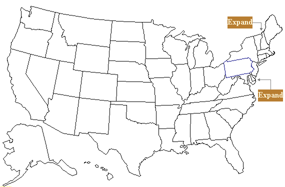
Map of the United States
with
Names, Postal Abbreviations, Capitals, Call Sign Areas,
Nicknames, Flags, and County Lists.
Click or touch any state to reveal the state's name, postal abbreviation, capital city, and amateur radio callsign area.
Select the button to see the state's nickname, state flag, and amateur radio contest county list.
Select the  button to return to the map to make another selection.
| AL |
| AK |
| AZ |
| AR |
| CA |
| CO |
| CT |
| DE |
| FL |
| GA |
| HI |
| ID |
| IL |
| IA |
| IN |
| KS |
| KY |
| LA |
| ME |
| MD |
| MA |
| MI |
| MN |
| MS |
| MO |
| MT |
| NM |
| ND |
| NE |
| NC |
| NJ |
| NH |
| NV |
| NY |
| OR |
| OK |
| OH |
| PA |
| RI |
| SC |
| SD |
| TX |
| TN |
| UT |
| VA |
| VT |
| WA |
| WY |
| WI |
| WV |
| Full Name: |
|
| Postal Code: |
|
Call Area: |
|
| Capital: |
|
|
|
|
|
|
|